Jamestown · plate 01
Jamestown Island: the fort site and the church tower
The English fort of 1607 was long thought lost to the river. Archaeologists found it in 1994. Today the island shows its outline, a brick tower and the people on both sides of the story.
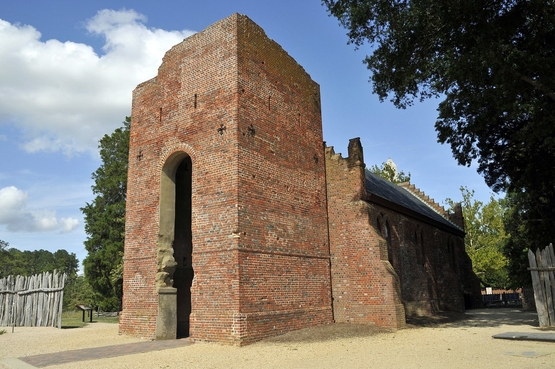
Jamestown Island sits at the western end of the Colonial Parkway, a low, marshy island in the James River about nine miles from Williamsburg. It is where the Virginia Company's colonists landed in May 1607 and built the fort that became the first permanent English settlement in North America. It is also a place where a great deal of what people once believed turned out to be wrong, which is one of the best reasons to visit.
Whose land it was
The English did not arrive in an empty country. The island lay within Tsenacommacah, the territory of the Powhatan paramount chiefdom, a network of some thirty or more communities in the coastal plain of Virginia under the leadership of Wahunsenacah, whom the English called Powhatan. The nearest people were the Paspahegh, on whose land the fort was built.
Relations swung between trade, uneasy alliance and open war. The colonists depended on Powhatan corn in the early years, and the chiefdom's leaders weighed whether these newcomers could be useful or should be driven out. Pocahontas, Wahunsenacah's daughter, appears in the story as a girl visiting the fort, later as a captive and then as the wife of the colonist John Rolfe. Her statue stands on the island today, and the panels around it now tell more of the Powhatan side than they once did.
The fort that was not lost
For most of the twentieth century, it was widely accepted that the site of James Fort had been washed away as the river ate into the island's shore. In 1994 an archaeological project began digging near the old church tower to test that idea. Within a few years the team had found the stains of the fort's timber walls in the soil, then its corners, its buildings, its wells and hundreds of thousands of artefacts.
The fort was triangular, built of upright logs set in a trench, with round bulwarks at the corners for cannon. Only a small part of it had been lost to the river. Today the outline is marked on the ground with posts and reconstructed sections of wall, so you can walk the shape of the settlement and stand where its first buildings stood.
Only a small part of it had been lost to the river.
The finds are shown in a small museum on the site, often called the Archaearium. They range from armour and coins to tools, trade beads and the remains of meals, and they tell a story of hard work, hunger and contact with the Powhatan world. Some of the most sobering evidence comes from the winter of 1609 to 1610, the Starving Time, when most of the colonists died; remains found in 2012 showed that desperate survivors had resorted to cannibalism.
The church tower and New Towne
The oldest standing structure on the island is the brick church tower, built in the late seventeenth century and now the only above-ground survivor of the colonial town. Beside it stands a memorial church built in 1907 on the foundations of earlier churches. In an earlier church on this spot, the first representative legislative assembly in English America met in July 1619.
A neighbouring plate · JamestownThe Glasshouse and the island loop driveA failed glass factory and a road through the marshEast of the fort lay New Towne, the later town that grew as the colony expanded. Its streets, house foundations and the statehouse are now marked by low brick outlines and signs in a grassy landscape. Jamestown remained the capital of Virginia until a fire destroyed the statehouse in 1698 and the government moved inland to Middle Plantation, soon renamed Williamsburg. After that the town faded, and by the eighteenth century the island was mostly farmland.
1619 and those who were enslaved
The year 1619 is remembered for two reasons. That summer the General Assembly met for the first time. A few weeks later, an English ship brought some twenty or more Africans, captured from a Portuguese slave ship, to Point Comfort near present-day Hampton; some were later brought to Jamestown. They are the first Africans recorded in the English colony. Their exact status, and how quickly slavery hardened into law, is debated by historians, but their arrival marks the start of a history that shaped everything that followed in Virginia. The site's displays deal with it directly.
Why here, of all places
Standing on the island, many visitors wonder why anyone would choose this spot. The Virginia Company's instructions told the colonists to settle well upriver, out of sight of Spanish ships, on ground that could be defended. Jamestown Island fitted: it was nearly cut off from the mainland by marsh, and deep water ran close to the shore, so ships could tie up to the trees.
The drawbacks became clear quickly. The low ground was swampy, the river water near the fort turned brackish and foul in summer, and disease killed many settlers in the first years. Recent research on tree rings suggests the colonists also arrived during a severe drought, which made their reliance on Powhatan corn more desperate and strained relations further.
The island itself has changed since 1607. The shoreline has moved, a narrow neck that once joined it to the mainland has been cut, and rising water threatens parts of the archaeology. The site's managers now spend real effort protecting the shore, because the ground itself is the record.
Seeing it well
The island is managed jointly by the National Park Service and a private preservation organisation, and one ticket generally covers the visitor centre, the fort site, the museum and the island drive; check current arrangements and charges before you go. Allow at least half a day, and more if you want to walk the whole of New Towne and sit in on a talk at the dig. Rangers and archaeologists often give talks at the dig, which is still active in season, and they are the best way to understand what you are looking at.
The island is low, wet and wooded at its edges. Mosquitoes and ticks are common in warm months, and the summer humidity is heavy. April, May and October are the kindest months on the island. After your walk round the fort and New Towne, the island loop drive takes you through the marshes and woods where the colonists cut timber and hunted.
Jamestown is easy to pair with the state's re-created settlement a mile away, described on the plate for Jamestown Settlement, which shows reconstructed ships and buildings. The difference is worth keeping straight: here on the island is the real ground, the real finds and the real tower; there is a careful re-creation. Drive back east along the Colonial Parkway towards Williamsburg and you follow the colony's own story inland, from the river's edge to its next capital.